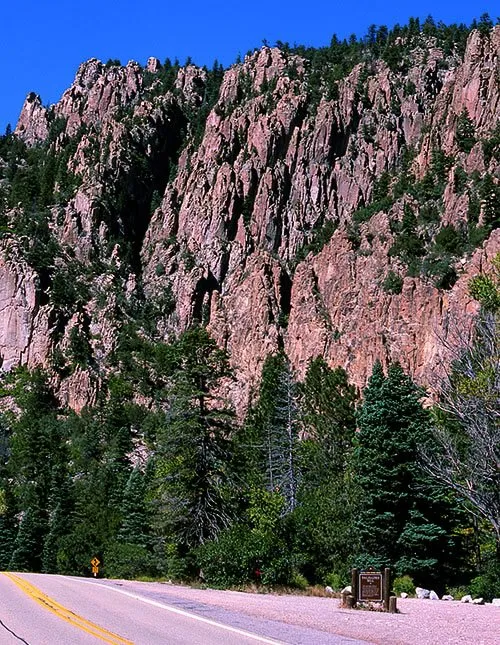
Drive east from Eagle Nest on U.S. 64, follow the Cimarron River out of Eagle Nest Lake, and the valley narrows into Cimarron Canyon. The road runs through Cimarron Canyon State Park, part of the 33,116-acre Colin Neblett Wildlife Area, where the land rises from about 7,400 feet along the river to 12,045 feet at Touch-Me-Not Mountain. In the eastern canyon, pale cliffs rise straight above the highway. Those cliffs are the Palisades, and for a rockhound they are the best outdoor geology lesson in the Eagle Nest country.
The New Mexico Bureau of Geology and Mineral Resources notes that Cimarron Canyon exposes nearly two billion years of geologic history. The canyon separates older Proterozoic rocks to the south from younger Tertiary rocks to the north, divided by the Fowler Pass fault. Southwest of that fault are quartzite, amphibolite, and granite that were heated and squeezed deep in the crust. The Bureau dates that granite at about 1.4 to 1.5 billion years old, with the surrounding metamorphic rocks between about 1.6 and 1.9 billion years old.
The Palisades are much younger. Molten rock pushed sideways between older sedimentary and metamorphic layers and cooled underground as a sheet geologists call a sill. The Bureau describes the sill as light gray and fine grained, dated at 34.7 million years by one method and as young as about 26 million years in more recent studies. The same sill also forms Touch-Me-Not Mountain. Its texture is the key to identifying it: visible crystals of plagioclase, biotite, hornblende, and quartz set in a fine gray matrix. Geologists call that texture porphyritic, and porphyritic dacite is the best name for the rock.
That texture tells how the sill cooled in stages, slowly at first so the larger crystals could grow, and then faster, forming the fine matrix around them. As the rock cooled, joints formed, and water that seeped into those cracks froze, expanded, and thawed over thousands of winters, prying the wall into the long columns and towers we see today. The Cimarron River did the final carving. The Bureau notes that it is the only watercourse that has cut through the Cimarron Range, because it drains the entire Moreno Valley.
For rockhounds, the canyon is a lesson in looking before collecting. Small prospects from the Elizabethtown mining boom era are scattered in the area, including the Horseshoe prospect, a short tunnel dug along quartz veins in the old metamorphic rocks, where pyrite that probably carries traces of gold and the copper mineral malachite have been found in dump samples. None ever produced economic amounts of ore, and the area is protected from mineral exploration and development. The reward here is practice in spotting quartz veins, dark hornblende and biotite crystals, and porphyritic texture in place.
Know before you go
Enjoy the Palisades for looking, learning, and photography, and do not collect rock there. The canyon is a state park and wildlife area, and the area is protected from mineral exploration and development. Collect only where collecting is legal. On Bureau of Land Management land, rockhounds may collect reasonable amounts for personal use, not for sale or barter, with hand tools and only minor surface disturbance, but not in developed recreation sites, and not on a mining claim without the claim holder's permission. Much of the Moreno Valley is private ranch land laced with old claims, so private land and claims are off limits without permission. Leave cultural items where you find them, respect posted signs, check with the local land manager when in doubt, and pack out everything you pack in.